


We’re asking residents for their views on proposed improvements to major junctions on Plymouth’s Major Road Network (MRN).
The plans are focused around three key sections along the route – Marsh Mills Roundabout, Embankment Road and the St Budeaux Bypass – and includes lane widening, junction capacity upgrades and new facilities for pedestrians and cyclists.
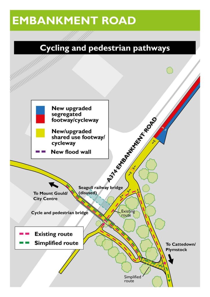
To help break down each aspect of the scheme, here is the last in a series of features about the different aspects of the plans, this time focussing on the Embankment and Arnold’s Point.
Have a read through and then head to www.plymouth.gov.uk/MRN to give us your thoughts.
The consultation closes on Friday 20 March.
As one of the key routes into Plymouth, the stretch of Embankment Road between Arnold’s Point and the cycle bridge, is a place thousands of people travel through every day, whether they are heading to work, driving into the city, or using the path alongside the river to walk or cycle.
It is a route with huge potential, but also one that is starting to show its limits, particularly for people trying to get around without a car.
The proposed improvements here aim to make the area safer and easier to use, while also tackling a growing issue that is becoming impossible to ignore; the increasing risk of flooding.
The shared walking and cycling path that runs along the southern side of Embankment Road is an important link in Plymouth’s Strategic Cycle Network. It connects residential areas like Plympton and Leigham with major employment centres in Cattedown and the city centre.
Like many sections on this route, the path at Blagdon’s Meadow is far too narrow for the number of people using it. Cyclists and pedestrians often have to squeeze past each other which can feel uncomfortable and unsafe, especially during busy times.
To fix this, the plan is to upgrade around 1.2 kilometres of the route into a fully segregated facility so that people walking and people cycling each have their own dedicated space.
At Blagdon’s Meadow there are two possible ways this could be done.
One option keeps the existing path alignment and simply widens it, although doing so would require removing trees both within the meadow and along Embankment Road.
The alternative option keeps the current path for cyclists but creates a new pedestrian route that weaves through the meadow instead.
Alongside the walking and cycling upgrades is another major piece of work that is becoming more urgent each year.
Arnold’s Point and the surrounding stretch of Embankment Road sit between the Plym Estuary on one side and vital rail infrastructure on the other.
As sea levels rise, the risk of flooding is increasing for nearby homes, the main road into Plymouth from the east, and the railway line that connects Plymouth and Cornwall with the rest of the country.
The existing flood defence wall has already prevented three potential flood events since it was built in 2013, but predictions suggest that by 2050 this area could flood roughly once a year if nothing is done.
To stay ahead of this, the MRN scheme is working with the Environment Agency to extend the current flood defence by around 1.2 kilometres all the way to Blagdon’s Meadow.
The new wall is being designed not only to protect the area but also to fit into the landscape more sensitively including adding a watertight glass section on the top so people can still enjoy the views across the estuary without compromising on safety.
The alignment of the new flood wall is tied closely to the design of the improved walking and cycling routes. This is why the same two options being considered for the path at Blagdon’s Meadow are also being looked at for the wall.
In addition to the proposal on Embankment Road and Arnold’s Point, the plans also include the removal of Seagull Bridge.
This redundant rail bridge has a height restriction of 4.8m, forcing high-sided vehicles to use alternative routes which are often less direct and unsuitable for HGV traffic.
Together, the improvements planned for this area of the project are about future proofing an important route and creating better ways for people to move around the city.
It is a chance to make the area safer, greener and more enjoyable for everyone who uses it, while putting essential flood protection in place for the decades ahead.
Please give us your views on the scheme at www.plymouth.gov.uk/MRN
